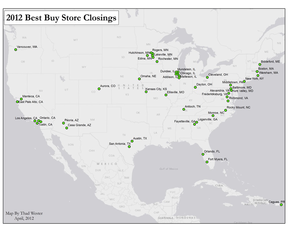
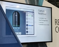
Leica announced a new laser scanner at Autodesk University last week. I attended and spent a few hours with members of the Autodesk and Leica teams. The new scanner from Leica and ReCap mobile workflow could usher in a significant shift in reality capture for buildings.
2 Comments
3D scanner accuracy is often tossed around loosely in spec-sheets and by sales reps. 1mm @ 25 feet, beam divergence, compensator accuracy... - it is very confusing and often does not reflect the true accuracy. Understanding the real world accuracy of a 3D scan is very important as most point cloud users expect point clouds to be perfectly accurate. Here we set out to test the real world accuracy of the Matterport 3D scanner.
Wanted to share/store my thoughts on why we bought a UAV (drone, quad-copter whichever you call it), and what we are looking to get out of the experience. A colleague of mine is being accused of damaging an adjacent residential property when a pipe busted in his storage shed on the rear of his property, during a winter storm earlier this year. The busted pipe released approx. 1 quart/min. of water onto the ground.
The question is: does water flow towards the adjacent property? We can answer this quickly with LiDAR. Have been working on developing building footprints from aerial imagery and LiDAR data that required an NDVI calculation and wanted to share the best workflow that I have found. You can read more about what a Normlized Difference Vegetation Index (NDVI) is here. Color aerial photo (left) and NDVI calculation (right). Notice how roofs, roads and vegetation are well defined in the NDVI image.
I am excited to announce that I have been asked to join LiDAR News as a Distinguished Contributor. LiDAR News is one of the largest information points for laser scanning on the internet and the only dedicated laser scanning print publication. I was asked to begin contributing content a few weeks ago and had my first article published online yesterday. The article will also be published in the LiDAR News print publication next month. "The Point," BHI, NC I was approached by a resident of Bald Head Island, North Carolina (BHI) and questioned about the different dune ridges that span the island, and in particular the dune ridge than runs beneath their house. So I mapped the island to determine the location of the dune ridge and possibly shine some light on their history. I have a background in Geomorphology (the study of how landscapes change), so I also provided some information regarding the processes that have worked (and are still working) to shape BHI. LIDAR derived 3D estimation of tree height. I put together a poster advertisement, displaying a few of the analyses I could do for practicing foresters in the region. Forestry is inherently geographic, so it wasn't difficult to "dream-up" some examples. Some of the examples are basic (imagery) while others are more advanced (tree height, visualizations). |
|