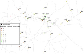
Map of attainable bandwidth
Today bandwidth is King.
An increasing number of services ride on the all-encompassing internet connection. This has done three things to the rural telecommunication business:
An increasing number of services ride on the all-encompassing internet connection. This has done three things to the rural telecommunication business:
1) Dampened their traditional business model (selling telephone). Problem
2) Required that they build out their networks to increase bandwidth. Long Term Solution
3) Provided the demand for expensive higher capacity bandwidth packages, facilitating a new revenue stream for rural telcos. Short Term Solution
To increase revenues in the short term, selling the residential customer or local business more bandwidth requires that you know the amount of bandwidth you can provide at a given location.
Currently all rural telco's do this by equating distance to bandwidth. This is inaccurate and makes it difficult to accurately estimate the quantity and quality of services that can be provided at a given location.
There is a better way, if you have a GIS.
Every DSL provider has a DSLAM, (a piece of hardware which is a routing point for subscribers). The DSLAM provides ATTAINABLE BIT RATE calculations every 15 seconds. Calculations not estimations. It treats every modem on the network as a sensor, constantly checking and reporting the available bandwidth.
So why are people measuring and estimating instead of getting the real deal values from the DSLAM? I have no idea.
If someone were to integrate this into a live map it would allow you to monitor network health, increase the accuracy of GIS based network build-out planning and provide the ability to know the exact number of customers that could be marketed to for a specific service.
That would be a huge accomplishment, not to mention you would have a massive market of interested buyers.

