Thad Wester
  • Home
  • School Experience
    • Research >
      • GAP Fire
      • Station Fire
      • Pea Island
      • TLS of a Forest
      • Chalk Cliffs
      • Masters Thesis
    • Terrestrial Laser Scanning >
      • USS North Carolina
      • Schooner Virginia
      • Debris Basins
      • Point Cloud Modeling
  • Contact Information
  • Blog

How Accurate is a Matterport 3D Scanner

7/14/2016

20 Comments

 
3D scanner accuracy is often tossed around loosely in spec-sheets and by sales reps. 1mm @ 25 feet, beam divergence, compensator accuracy... - it is very confusing and often does not reflect the true accuracy.  Understanding the real world accuracy of a 3D scan is very important as most point cloud users expect point clouds to be perfectly accurate.  Here we set out to test the real world accuracy of the Matterport 3D scanner.


What is Matterport

The Matterport 3D scanner is a low cost (~6,000 usd) tripod mounted scanner.  The scanner is designed to be easily used by anyone and the main deliverable are 360 tours (very beautiful I might add).  As a bonus a 3D model is created automatically from the scans and can be downloaded as a point cloud and imported into Revit/AutoCAD/PointCAB etc...

Matterport has focused on its virtual tour deliverable, however it can produce a point cloud and so it is an interesting potential cheap solution for those looking to dip their toe into 3D scanning or introduce point clouds on a project.
​

Method

To test the accuracy we scanned a 6,000 sqft floor with a Leica P20 and again with the matterport.  The Leica P20 is an amazing instrument, (with a price tag of ~120k new, it should be) and for our purposes is perfectly accurate within a floor of this size. The comparison will highlight any shortcomings regarding accuracy of the Matterport 3D Scanner.
​

Results

We will test the accuracy in the horizontal (x/y), vertical (z) and levelness.  Data is lined up manually in Revit for analysis.

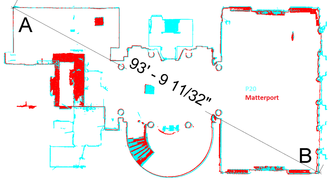
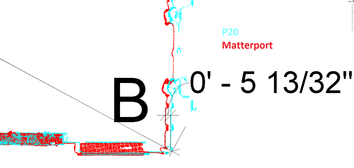
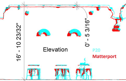
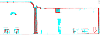
                                                RED is the Matterport data, BLUE is the Leica P20
​
Horizontal Accuracy
Picture
Picture

Vertical Accuracy
Picture

Levelness
Picture
Picture

Discussion

The horizontal accuracy is off ~5.5 inches over ~90 feet.  5.5 inches seems like a lot, but over 20 feet the accuracy should be around 1 inch, which seems reasonable.

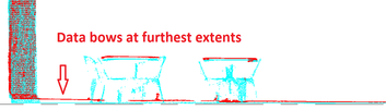
The vertical accuracy shows a deviation of ~5 inches over a mere ~17 feet.  This deviation is consistent across the entire floor.  The reason for the large error is due to the dramatic falloff in accuracy with distance.  The Matterport sensors cannot shoot directly up, and in order to reach the ceiling they measure at an angle and at the furthest extents of their range.  Matterport suggests scanning closer together, or lifting the scanner on a high tripod to provide more accurate data on high ceilings.
​
The overall levelness of the data is excellent.  No real difference between the Matterport and the p20.  However, at the ends of the floor there is a "potato chip" warping effect.  This is probably the same effect occurring on the ceiling: data far away from the scanner is less accurate (there were no scans directly near these areas).

​One thing to note, we needed 2.5 times as many scans for the Matterport compared to the P20. This is due to the short range of the Matterport scanner.  

Written by Thad Wester and Ben Yoder, ​Their views are their own and not necessarily those of WeWork.

​
20 Comments
Ed Baker link
7/26/2016 08:29:40 am

Good work on the topic. I often wondered about that. All I ever got from Matterport was +/- 2%.

Were your numbers from the .obj files that came out of the Matterport scans?

I use Matterport but only as an alternative when illustrative is an option and accuracy is not. Generally (for me) rooms are under 30'

Again, good insight!

Ed
vcnw@comcast.net

Reply
Thad
7/26/2016 08:47:31 am

Hi Ed,
We used the obj file (converted into a point cloud), and also a raw point cloud file provided by Matterport. They were virtually the same.

Yeah, generally it is good enough for most work. Just have to keep an eye on the points and surfaces over 10 feet from the scanner, as those can be off by more than 1-2%.

Reply
Sherry Rennick link
8/30/2016 10:04:23 am

Based on your comparisons and date, I am wondering how I can market Matterport to industries that would find this to be valuable. We, of course, work for the real estate industry and are beginning to work with builders in providing them construction status updates. Based on delivering the OBJ file, who would this be valuable to? What industries and how should it be marketed? Any advice?

Reply
Ed link
8/30/2016 10:41:14 am

The value is in the ability to save the architect, engineer, inspector, bidder, banker, and public safety official time and money by not having to go to the location. By being able to see it virtually with a fairly high degree of accuracy the enduser would be able to;
Sign off on permits/inspections
Have As-built plans when completed
Release funds for the next phase of constructions
Clear understanding of the floor plan before you enter the building
Expedites services through collaboration and email links

I just touched on a few but I think it makes the point. Time is money and if one person can document a site letting multiple users do there jobs from an accurate HD showcase... why not right?

Hope my opinion helped!

Ed

Reply
Thad
9/7/2016 12:27:10 pm

Sherry,
its a tough sell and service to pull off, but it could be good enough for some niche scenarios.

My experience is that if they/anyone needs something measured it has to be right. The matterport is pretty good, but as you can see it isnt perfect.

Reply
Chris link
8/31/2016 03:15:55 am

Excellent piece of work. I would LOVE to see a similar comparison to www.dotproduct3d.com which I believe uses the same (PrimeSense?) or very similar depth sensor and unlike Matterport is targeted specifically to be used in this application.

Reply
Thad
9/7/2016 12:31:56 pm

Chris,
Dot wont be very accurate at all at this scale (100 feet). Its designed for very niche applications - small scales and difficult areas to reach.

Reply
Dan Prochazka link
8/31/2016 04:07:08 pm

Thanks for this great write up Thad.

Matterport is running an open beta on colored point clouds. Anyone interested in getting point clouds from their model can send a request to aec@matterport.com. Just include the model link.

Reply
Thad
9/7/2016 12:32:34 pm

excellent. More point clouds the better!

Reply
Simon M
9/16/2016 09:45:26 am

Thank you Thad! A very useful piece of '3rd party' comparative research / validation. For precision engineering measurement it would matter (no pun intended). The question in my mind as a Matterport user is whether a more accurate device could evolve / be justified to deal with the vertical, greater distances between scans, and to me important a much higher resolution photograph. A real challenge would be introducing a secondary non-IR scanning tech to deal with sunlight. The latter would truly extend the market.

Reply
Jamie henry
9/16/2016 03:36:03 pm

I've been a matterport user for quite some time. I primarily use it for floor plans so accurate measurements are important.
I always use a laser scanner and compare it to the workshop measure tool (not an extracted obj file)
While it's generally different at a larger distance, it does fall within 98% accuracy if you have scanned correctly.
I have scanned an area with a room length of 200 feet and the matterport came in at 99.2% of the laser measurement. For me that's close enough.
If however you do need higher accuracy, then this camera is not for you. Just be prepared to shell out some serious dollars for the extra 2%

Reply
Isaac
3/15/2018 11:09:30 am

Hi Jamie,

I do As-built surveying for architects and contractors who need plans of existing houses or commercial spaces typically ranging from 1,500 SF to 33,000 SF. I currently use a laser measures and jot down on paper, then draft it on computer. I'm desperately looking for an alternative. I'm considering the Matterport (although I know its intended as 3D Camera and not a 3D scanner) because of its decent price-tag. Would you recommend me to use the Matterport? If I do more scans per space, (which I'm fine doing, if that's what it takes...) can I get a reliable accuracy?

Thank you!

Reply
VR Content
1/24/2017 01:57:15 am

You can convert from a Matterport obj file to a point cloud file at https://virtualcontent.ecwid.com.

Reply
Robert Manetta link
9/26/2017 10:05:30 am

Thad,

This news may be of interest to you.

--Robert

Leica Geosystems, Matterport partner to deliver AEC solution

Effort aims to provide comprehensive offering for construction lifecycle

(Heerbrugg, Switzerland/Sunnyvale, USA, 26 September, 2017) – Leica Geosystems, industry leader in measurement technology, and Matterport, the world’s leading cloud-based 3D media company, today announced a partnership to deliver a fast, simple solution for creating, modifying, distributing, and navigating immersive 3D and digital images. The effort is aimed at the Architecture, Engineering and Construction (AEC) sector.

The partnership is focused on integrating the new Leica BLK360 imaging laser scanner and encompassing Multivista’s construction progress documentation services into Matterport’s cloud-based platform. The solution is expected to offer an easy, flexible and automated way of capturing detailed images and using the resulting data to create immersive 3D visualisations.

“With our new partnership with Matterport, combined with our recent acquisition of Multivista, we are fulfilling our commitment to supporting the AEC industry and bringing the sector added value,” said Hexagon Geosystems President Juergen Dold. “As AEC professionals continue to progress their work in the Design, Build and Maintain (DBM) lifecycle, we are there with them supplying the solutions they need to achieve their goals. With this latest offering, these professionals can now easily visualise their projects to shape the change needed in a digital reality for real world advancements, leading to reduced costs and increased time savings.”

Hardware, software and platform in one
The integration of technologies from Leica Geosystems and Matterport is designed to create a complete solution that simplifies capture, automates reconstruction and provides the ability to integrate third-party apps. It is further amplified by artificial intelligence (AI) technology which provides an added level of intelligence, automation, and time savings. The extremely simple user experience includes real-time feedback and is designed to enable the capture and confirmation of images and 3D data from both the BLK360 imaging laser scanner and Matterport Pro2 camera on-site, resulting in lower costs, less time on site, and quicker deployment across a distributed set of projects. For the customer, this means not only a revolutionary new way to capture a space but, in addition, it enables immersive visualisation and the most state-of-the-art way to interact and collaborate around a real-world space.

“We are excited to be aligning with the market-leaders to integrate the new BLK360 imaging laser scanner and support end-user applications to serve a broader range of use cases," said Bill Brown, Matterport CEO. "As the leader in next-gen 3D reality capture and distribution, we are focused on offering an end-to-end platform that is extremely easy to use, quick, and inexpensive. Our new partnership with Leica Geosystems plus our recent Multivista partnership are huge steps forward in this platform development."

Leica Geosystems and Matterport expect to deliver the integrated solution to the AEC market in 2018.
For more information about the Leica BLK360, please visit http://leica-geosystems.com/en-us/products/laser-scanners/scanners/blk360
.
For more information about Matterport’s cloud-based platform for AEC, please visit https://matterport.com/3d-scanning-construction-engineering/

Matterport is an immersive media technology company that delivers an end-to-end system for creating, modifying, distributing, and navigating immersive 3D and virtual reality (VR) versions of real-world spaces on the Web, mobile devices, and VR headsets. The Matterport Pro2 Camera and Cloud Services make it quick and easy to turn real-world places into immersive virtual experiences. To learn more, visit http://www.matterport.com, the Matterport Gallery, the Matterport Community or visit us on social media.

Hexagon Geosystems is the complete reality-capture solutions provider. With a sharp focus on information technologies that capture, measure, and visualise data, our high-quality products and solutions create real digital worlds. With more than 4,500 employees in 33 countries operating technology and service centres on three continents with partners in 120 countries, we have the global reach to work with organisations through precise measuring instruments, engaging software, and trusted services.
Hexagon Geosystems is part of Hexagon (Nasdaq Stockholm: HEXA B; hexagon.com), a leading global provider of information technology solutions that drive productivity and quality across geospatial and industrial landscapes.

Reply
Forrest Huff link
1/30/2018 03:59:29 pm

I'm curious if the "april tags" have improved the stitching process and increased the accuracy. Has anyone done a comparison to see how much improvement there is?

Reply
akshay link
5/10/2019 05:41:52 am

Terrestrial Laser Scanning System Market Growth 2019-2024 Terrestrial laser scanning (TLS) is a ground-based, active imaging method that rapidly acquires accurate, dense 3D point clouds of object surfaces by laser rangefinding. Terrestrial scanning uses a ground-based or tripod-mounted LIDAR to create high resolution 3D images of surfaces and objects. Download FREE Sample of this Report @ https://www.grandresearchstore.com/report-sample/global-terrestrial-laser-scanning-system-2019-2024-986

Reply
Ron Booker link
1/9/2020 07:34:56 am

Thanks for explaining that a Matterport scanner creates 3D models that introduce point clouds on a project. One of my aunts works as a real estate agent and the agency recently started working with construction builders, Maybe this method could benefit both into constructing new buildings with a 3D model as an example for new projects.

Reply
Miranda link
1/16/2021 06:52:42 am

Great blog post

Reply
3D laser scanning surveying link
8/31/2022 08:53:03 pm

Laser scan surveys gather millions of accurate points that create a 3D image which can be processed and used in nearly all CAD and 3D Modelling systems.

Reply
laser point cloud scanning link
12/12/2022 07:25:44 pm

Laser scan surveys gather millions of accurate points that create a 3D image which can be processed and used in nearly all CAD and 3D Modelling systems.

Reply


Leave a Reply.


    Thad Wester

    Founder @ Clarity Scanning.  Lead the WeWork Reality Capture team.  Likes tennis, ping pong and college football.

    Categories

    All
    Consulting
    Field Work
    Geomorphology
    Gis
    Introduction
    Misc
    Telecommunication
    Terrestrial Laser Scanning
    Tutorials

    View my profile on LinkedIn
Powered by Create your own unique website with customizable templates.