Thad Wester
  • Home
  • School Experience
    • Research >
      • GAP Fire
      • Station Fire
      • Pea Island
      • TLS of a Forest
      • Chalk Cliffs
      • Masters Thesis
    • Terrestrial Laser Scanning >
      • USS North Carolina
      • Schooner Virginia
      • Debris Basins
      • Point Cloud Modeling
  • Contact Information
  • Blog

Mapping viable zones of shrimp farming, Nicoya Bay, Costa Rica

2/15/2011

2 Comments


Picture
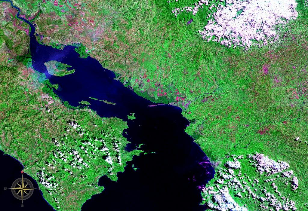
Gulf of Nicoya seen from space (false color)
The recent proliferation of GIS (Geographic Information System) has made it a common acronym in a multitude of fields.  You benefit from a GIS everyday, but you have probably never noticed. Think of the revolution of in-car GPS; an array of Global Positioning Satellites track you, but they don't track you through a blank screen, do they? No, the GPS places you amongst a detailed map of highways, streets, overpasses and lakes. That map of features is a GIS. A GIS allows its user to view the world in a very specific way, and the following is an excellent example of the power of GIS.

Introduction

My Advanced Coastal GIS course recently presented me with a fictitious but realistic problem; from an engineering perspective, asses the region surrounding Nicoya Bay, Costa Rica, for sites which are suitable for shrimp aquaculture.Thinking from an engineering perspective, we factored in building cost, shipping distance to a major city, proximity to both fresh (river) and salt water (10-25 ppt) and site elevation. Additionally, we decided to narrow down our site selections by opting to use already built Salinas (salt flats) for potential shrimp aquaculture.  Choosing a Salinas will lower building costs and reduce the risk of unforeseen problems inherent in new building locations.

Read More
2 Comments

Nodal Ninja 2

1/28/2011

0 Comments

 
I had written previously about the better image quality when using the Nodal Ninja setup, compared with the images of the built in web cam on the Leica C10.  Below is a comparison, but before you examine the images let me make a few statements.
1) The imagery from the web cam in this instance I consider to be very good.
2)  I took the scan images and the Nodal Ninja images on two separate days, so some stuff (chairs, bikes, book bags, etc...) changed position.  This results in the images and point cloud not matching up perfectly for the nodal ninja example.
3) The resolution of the scan was 1cm at 10m 360x270.
Picture
Web cam images overlaid onto the point cloud

Read More
0 Comments

Nodal Ninja

1/27/2011

0 Comments

 
Picture
Nodal Ninja setup
Took out our Nodal Ninja setup out for our Leica C10 laser scanner today. If you don't know what a Nodal Ninja is, it is a bracketed camera mount that fits into a terrestrial laser scanner's tribrach.  It provides a way of overlaying higher quality images onto scanned point clouds than are provided by the "web cam" like camera built into most laser scanners. The major advantage of the nodal ninja setup is that it enhances the color quality of the images and not so much that it adds resolution over the built in camera.

The images look incredible with our Cannon 5D Mark II with Sigma 8mm f/3.5 fish eye lens attached to the Nodal Ninja.  The unbelievable field of view of the fish eye lens and 5D's full frame sensor gives the panorama advantages over just about any other camera used with this setup, allowing for almost perfect coverage with only three pictures, and near perfect exposure without a flash in just about all lighting conditions.  This makes the camera ideal for taking pictures outside and from multiple scanning locations over the course of a day, since the 5D will give similar pictures regardless of the amount of sunlight.

I'm trying to get the work flow down for the Nodal Ninja so that we can use it next week on a scan project we have planned on the campus of East Carolina University.


More to come soon...
0 Comments

First Post

1/13/2011

1 Comment

 
Hello everyone!

After creating a website to archive all of my research/field work I have realized that a blog would be more appropriate and easier to follow as I progress through my last semester of graduate school.  This blog will mainly serve as a catalog for my work, but may grow to include information from around the industry.

Thad
1 Comment
Forward>>


    Thad Wester

    Founder @ Clarity Scanning.  Lead the WeWork Reality Capture team.  Likes tennis, ping pong and college football.

    Categories

    All
    Consulting
    Field Work
    Geomorphology
    Gis
    Introduction
    Misc
    Telecommunication
    Terrestrial Laser Scanning
    Tutorials

    View my profile on LinkedIn
Powered by Create your own unique website with customizable templates.