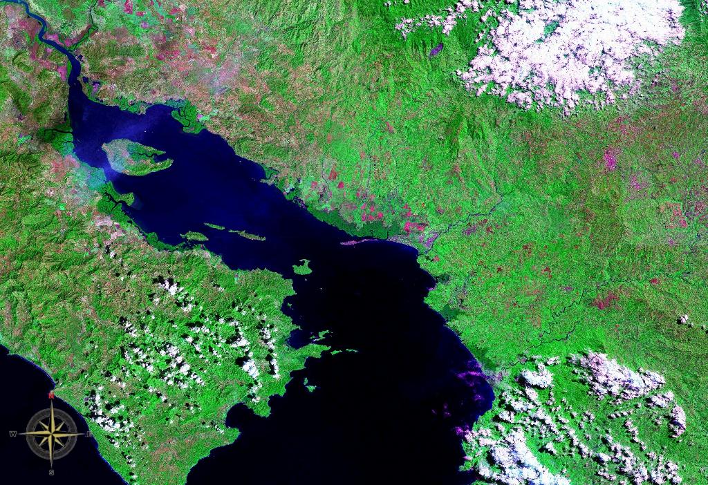
Gulf of Nicoya seen from space (false color)
The recent proliferation of GIS (Geographic Information System) has made it a common acronym in a multitude of fields. You benefit from a GIS everyday, but you have probably never noticed. Think of the revolution of in-car GPS; an array of Global Positioning Satellites track you, but they don't track you through a blank screen, do they? No, the GPS places you amongst a detailed map of highways, streets, overpasses and lakes. That map of features is a GIS. A GIS allows its user to view the world in a very specific way, and the following is an excellent example of the power of GIS.
Introduction
My Advanced Coastal GIS course recently presented me with a fictitious but realistic problem; from an engineering perspective, asses the region surrounding Nicoya Bay, Costa Rica, for sites which are suitable for shrimp aquaculture.Thinking from an engineering perspective, we factored in building cost, shipping distance to a major city, proximity to both fresh (river) and salt water (10-25 ppt) and site elevation. Additionally, we decided to narrow down our site selections by opting to use already built Salinas (salt flats) for potential shrimp aquaculture. Choosing a Salinas will lower building costs and reduce the risk of unforeseen problems inherent in new building locations.
Methods

A Salinas in the Canary Islands
The attributes of our final site selection entailed the site being: within 0.25 miles of a road, 0.5 miles of a river, within 5 miles of 10-25 ppt salinity water and within 3-10 meters above mean sea level. Being within 0.25 miles of a road allows easy access to the Salinas, reducing the expense of building roads, and minimizing travel on subpar, unsealed (dirt) roads. A Salinas within 0.5 miles of a river reduces the cost of piping fresh water to the site. In order to efficiently obtain the needed salt water and since salinity values change daily, we chose to have our site within a 5 mile buffer of the areas known to have salinity's levels of 10-25 ppt. Having a shrimp aquaculture pond within 3-10 meters above sea level has multiple advantages. One, it provides enough space between the ocean and the aquaculture pond to avoid sea water intrusion during a possible time of high water levels; two, it constrains the aquaculture site distance from the ocean (which is important for efficient piping of seawater to the site); and three, it avoids problems of choosing a site with a steep slope, which occur often on the land surrounding Nicoya, Bay which which is above 10 meters in elevation from mean sea level.
Goals : Maximize profit by minimizing the cost, minimize transport, and use the best suitable land for shrimp farming.
Criteria : Within 1/4 miles of a road; 1/2 from a river, Within 20 miles of Puntarenas; Nearby water salinity between 15-25%, Elevation between 3-10 meters.
Goals : Maximize profit by minimizing the cost, minimize transport, and use the best suitable land for shrimp farming.
Criteria : Within 1/4 miles of a road; 1/2 from a river, Within 20 miles of Puntarenas; Nearby water salinity between 15-25%, Elevation between 3-10 meters.
Results
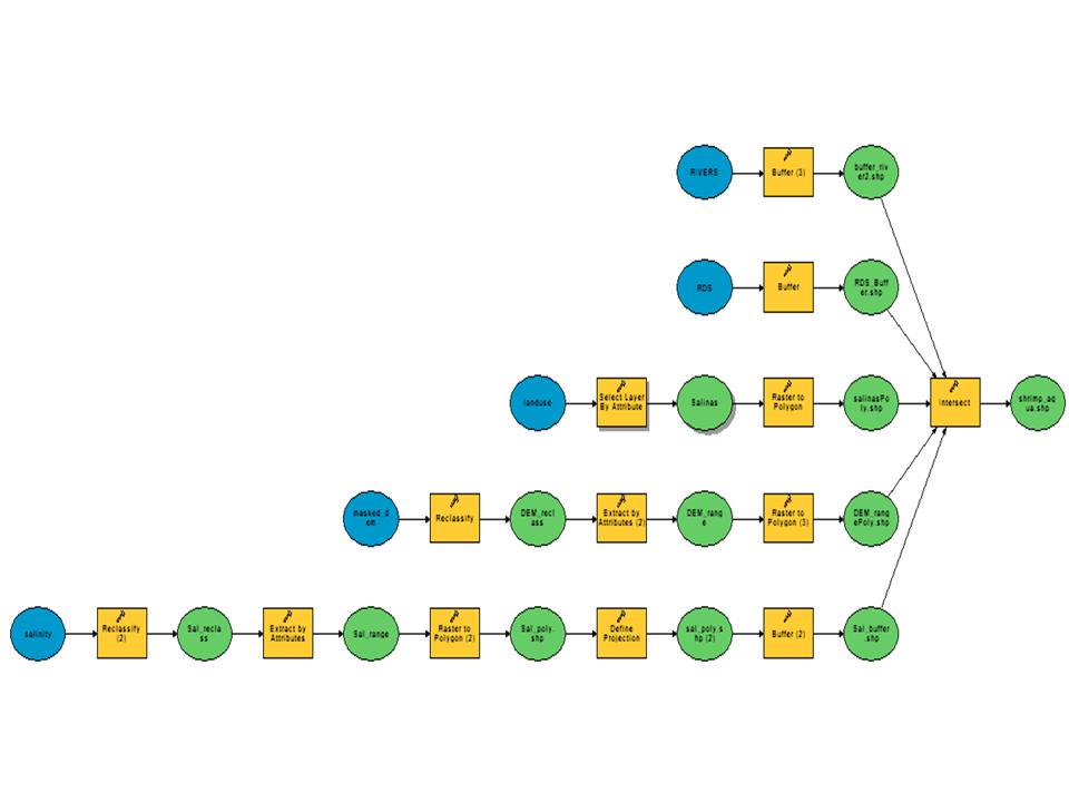
(Fig.1) Using ArcMap's Model builder to specify our parameters and data sets, potential areas for shrimp farming were mapped.
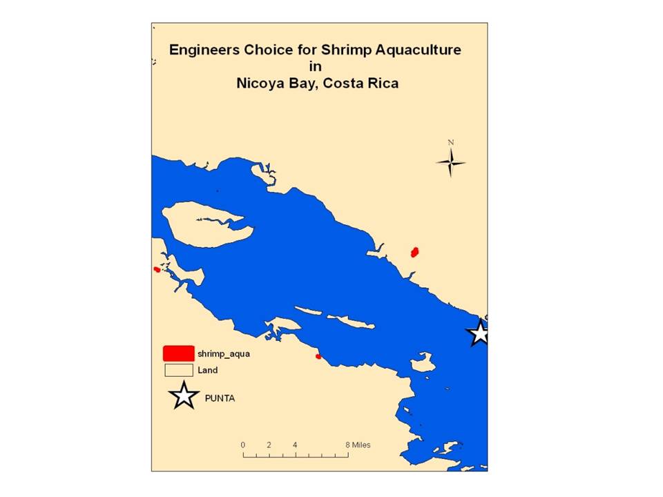
(Fig.2) Potential shrimp farming sites meeting the given criteria.
After running the model with the above parameters (Fig.1), I was left with several site choices; a cluster of Salinas's on the north side of Nicoya bay and two Salinas's on the south side of the bay. The Salinas cluster on the north side of Nicoya bay was deemed superior to the other Salinas for two reasons. The North shore cluster is half the travel time to the major city center near Nicoya Bay, Puntarenas, and additionally it allows for the expansion of our aquaculture shrimp operation, since there are multiple suitable sites nearby.
A review of relevant literature suggests there is a need for more remote sensing and GIS integration in the field of aquaculture. Rajitha et. al. (2007) suggests that GIS and remote sensing is a necessary management component of aquaculture, especially when used to identify unsustainable problem areas. However, the datasets needed for the analysis of land at scales which are beneficial for aquaculture are unorganized at best. The solution? The organization of homogeneous composite land development units and real time updating of time series information. Networks need to be developed so that information can be collected quickly, efficiently and at a resolution that benefits micro-scale applications, i.e. shrimp aquaculture.
A shrimp farmer looking to expand in Costa Rica would pay a lot of money to quickly and easily know the best places for his next shrimp farm. The right location could save him money, adding to his profits in the long term. The basic idea here, being able to choose the "best" location, isn't new. It doesn't take a computer to figure out that the best location for a store is on the corner, at the intersection of two busy roads. However, the ability to complicate the scenario with sophisticated variables (salinity level, proximity to roads etc.) extending over large areas is a seminal jump in efficiency and capability.
This is just one example of the capabilities of a GIS. More examples can be found here.
References
Rajitha et al., 2007 K. Rajitha, C.K. Mukherjee and R. Vinu Chandran, Applications of remote sensing and GIS for sustainable management of shrimp culture in India, Aquac. Eng. 36 (2007), pp. 1–17.

