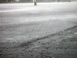
Rain on an impervious surface
Impervious surfaces are (mainly) artificial structures (roads, parking lots, rooftops) which pave and seal the soil surface preventing or greatly reducing rainwater infiltration. Impervious surfaces have a negative impact on the quality of surface water and the ability of ground water to recharge (replenish itself). Therefore, monitoring the spatial pattern and percentage of impervious surfaces relative to non-impervious is an important aspect of water resources management. Moreover, as urban areas become more populated the a need exists to quickly and accurately assess the percentage of impervious surfaces to non-impervious within a watershed is of increasing importance, so that timely and correct land-use decisions can be made by local managers.
The Impervious Surface Analysis Tool (ISAT) is an extension for ArcGIS which calculates the percentage of impervious surface area within a specified geographic area (i.e., watersheds, municipalities, subdivisions). ISAT results can also be used to predict how different management strategies could impact local water quality.
The Impervious Surface Analysis Tool (ISAT) is an extension for ArcGIS which calculates the percentage of impervious surface area within a specified geographic area (i.e., watersheds, municipalities, subdivisions). ISAT results can also be used to predict how different management strategies could impact local water quality.
Methodology
The boundaries of the watershed(s) were delineated using the protected and critical watersheds layer from the state of North Carolina. ISAT was used to estimate the percentage of impervious surface in the Lower Lumber River watershed only within the state of North Carolina. NOAA Coastal Change Analysis Program (C-CAP) data were used in the estimation of impervious surfaces.
Results
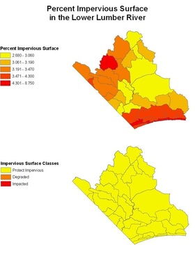
In the Lower Lumber River watershed ISAT estimated percent impervious surface percentages ranging from 2.68 to 8.75. The higher percentages are along the coast, where development is the most dense, and also near Whiteville, North Carolina, a small inland city. Zones of lower percentages of impervious surfaces are a result of agricultural intensive land use or the low lying area known as the Green Swamp (two large yellow watersheds in the right of the map).
While there are a spread of high and low relative percentage impervious surface values throughout the watershed, even so, all areas in the watershed are still classified as protect impervious, meaning that the percentage of impervious surfaces in the area are not large enough to impact water quality in a significant way.
While there are a spread of high and low relative percentage impervious surface values throughout the watershed, even so, all areas in the watershed are still classified as protect impervious, meaning that the percentage of impervious surfaces in the area are not large enough to impact water quality in a significant way.
Discussion
Limitations. 1) ISAT is more accurate when estimated for large areas and less accurate for smaller areas. 2) ISAT was developed for urban areas. North Carolina, and these sub-watersheds area in particular are very rural, with very little urban area, so there can be assumed to be inaccuracies with its application in the Lower Lumber River.
Suggestions 1) Higher resolution CCAP land cover data. 2) Updated census block data, 2000 data is 10 years old. Many areas in southern Brunswick county have grown rapidly in those 10 years.
Suggestions 1) Higher resolution CCAP land cover data. 2) Updated census block data, 2000 data is 10 years old. Many areas in southern Brunswick county have grown rapidly in those 10 years.


