For my Masters Thesis I am using Terrestrial Laser Scanned surveys from the GAP fire to investigate the effects of a recent wildfire on hydrologic and sedimentologic connectivity during the first significant rain event. Here I show examples of the captured terrain, hydrologic networks and their alteration, caused by the first significant rain event after the wildfire disturbance.
The surveys are both 1cm Digital Earth Models (DEMs). However, computationally the grids are larger than can be handled in ArcMap, therefore the DEM was re-sampled to a resolution of 2cm so that hydrologic networks could be calculated. Mean absolute errors for x, y, and z in both surveys were less than or equal to +/- 3mm. The procedures for hydrologic flow network delineation are based on the Deterministic 8 (D8) model for flow over a 2cm DEM. The D8 method produces a single flow direction towards the steepest slope of one of eight grid cells neighboring the initial center cell (O’Callahan and Mark, 1984; Tarboton, 2003). The D8 method was chosen for its simplicity and widespread use in hydrologic terrain analysis (Kiss, 2004).
The surveys are both 1cm Digital Earth Models (DEMs). However, computationally the grids are larger than can be handled in ArcMap, therefore the DEM was re-sampled to a resolution of 2cm so that hydrologic networks could be calculated. Mean absolute errors for x, y, and z in both surveys were less than or equal to +/- 3mm. The procedures for hydrologic flow network delineation are based on the Deterministic 8 (D8) model for flow over a 2cm DEM. The D8 method produces a single flow direction towards the steepest slope of one of eight grid cells neighboring the initial center cell (O’Callahan and Mark, 1984; Tarboton, 2003). The D8 method was chosen for its simplicity and widespread use in hydrologic terrain analysis (Kiss, 2004).
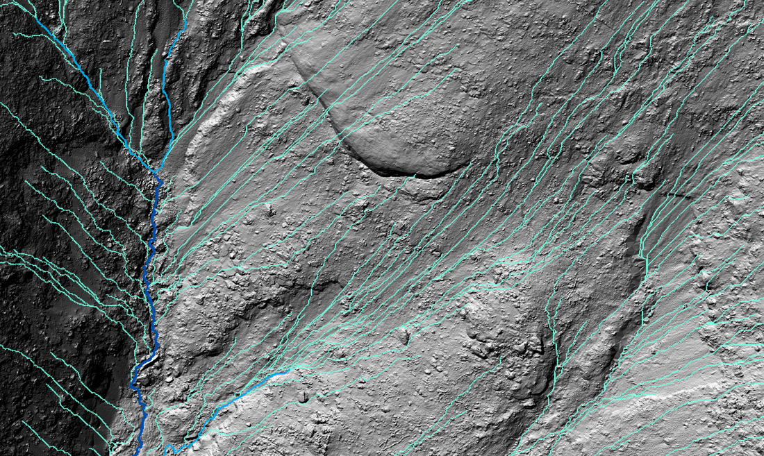
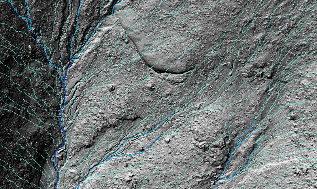
The above images show closeups of the pre (left) and post (right) rainfall surveys of the Wylie basin. Green lines represent rill networks, light blue represent gully networks and dark blue the channel. The curved feature in the center of the images is a bedrock outcropping.

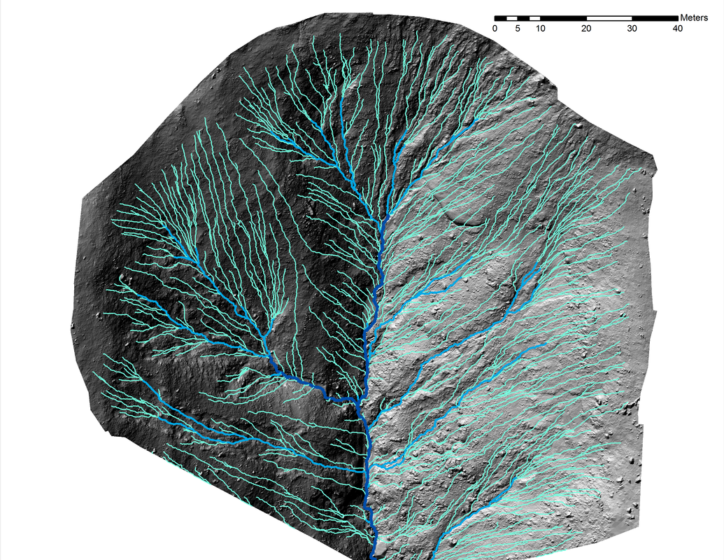
Above are the hydrologic networks of the Wylie basin pre and post rainfall. The D8 method produces a single center line for the hydrologic networks, however, each of the features (rill, gully, channel) have been widened for ease of viewing.
References
O'Callaghan, J. F. and D. M. Mark, (1984), "The Extraction of Drainage Networks from Digital Elevation Data," Computer Vision, Graphics and Image Processing, 28: 328-344.
Kiss, R.: Determination of drainage network in digital elevation model, utilities and limitations, Journal of Hungarian Geomathematics, 2, 16–29, 2004.
Tarboton, D.G. 2003 Terrain analysis using digital elevation models in hydrology, 23rd ESRI International Users Conference, San Diego, California.
This material is based upon work supported by the National Science Foundation (NSF) under Grant No. 0239749, entitled “CAREER: Alluvial Fan Form Quantification to Advance Geographic Science and Education” and Grant No. 0934131, entitled “Geomorphic Connectivity in a Recently Burned Watershed” - Thad Wasklewicz, PI
This material is also based upon work supported by a National Geographic Society CRE grant #8590-08 entitled “Rapid Assessment of Hydrological and Sedimentological Connectivity in a Recently Burned Watershed” - Thad Wasklewicz, PI

